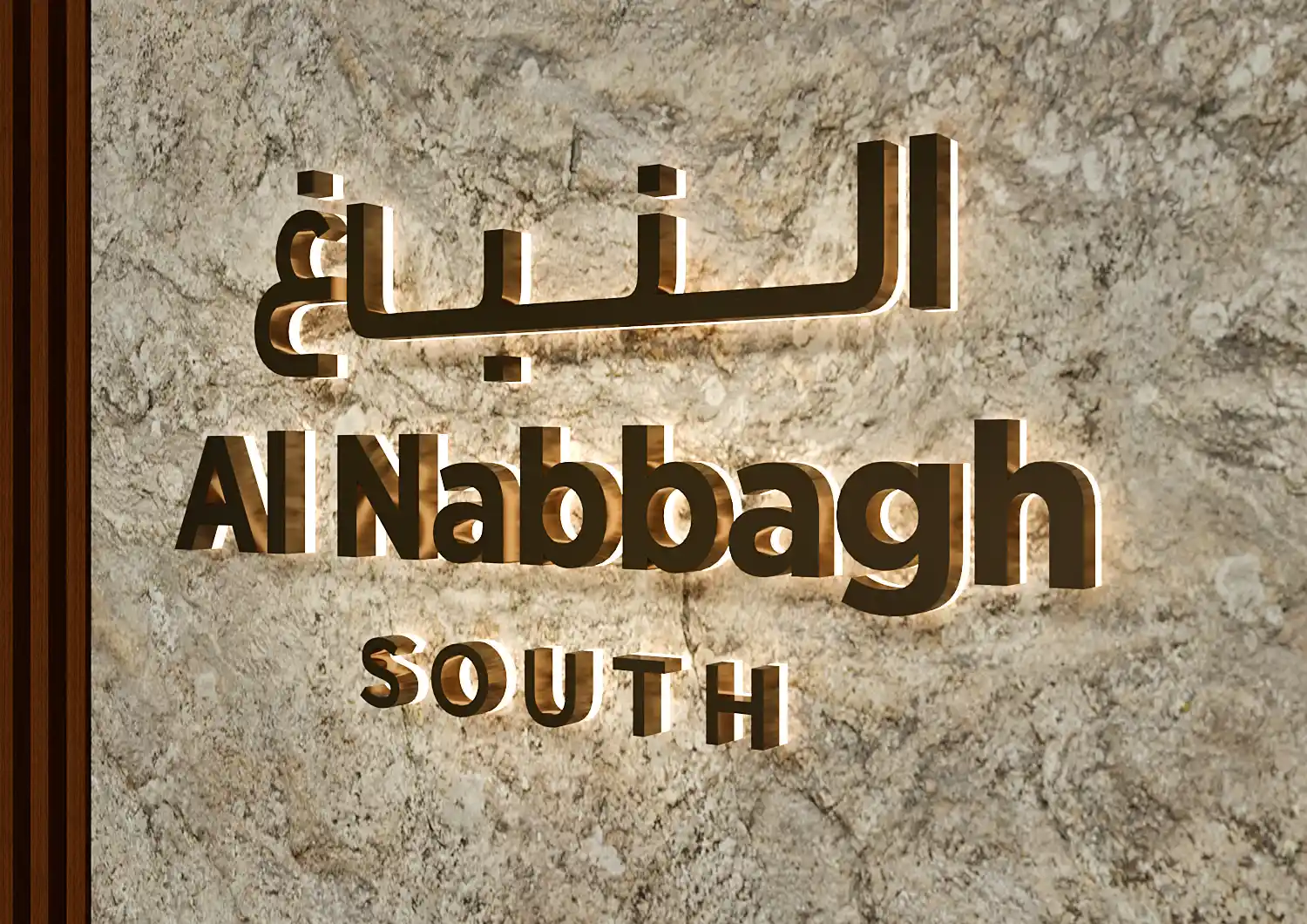

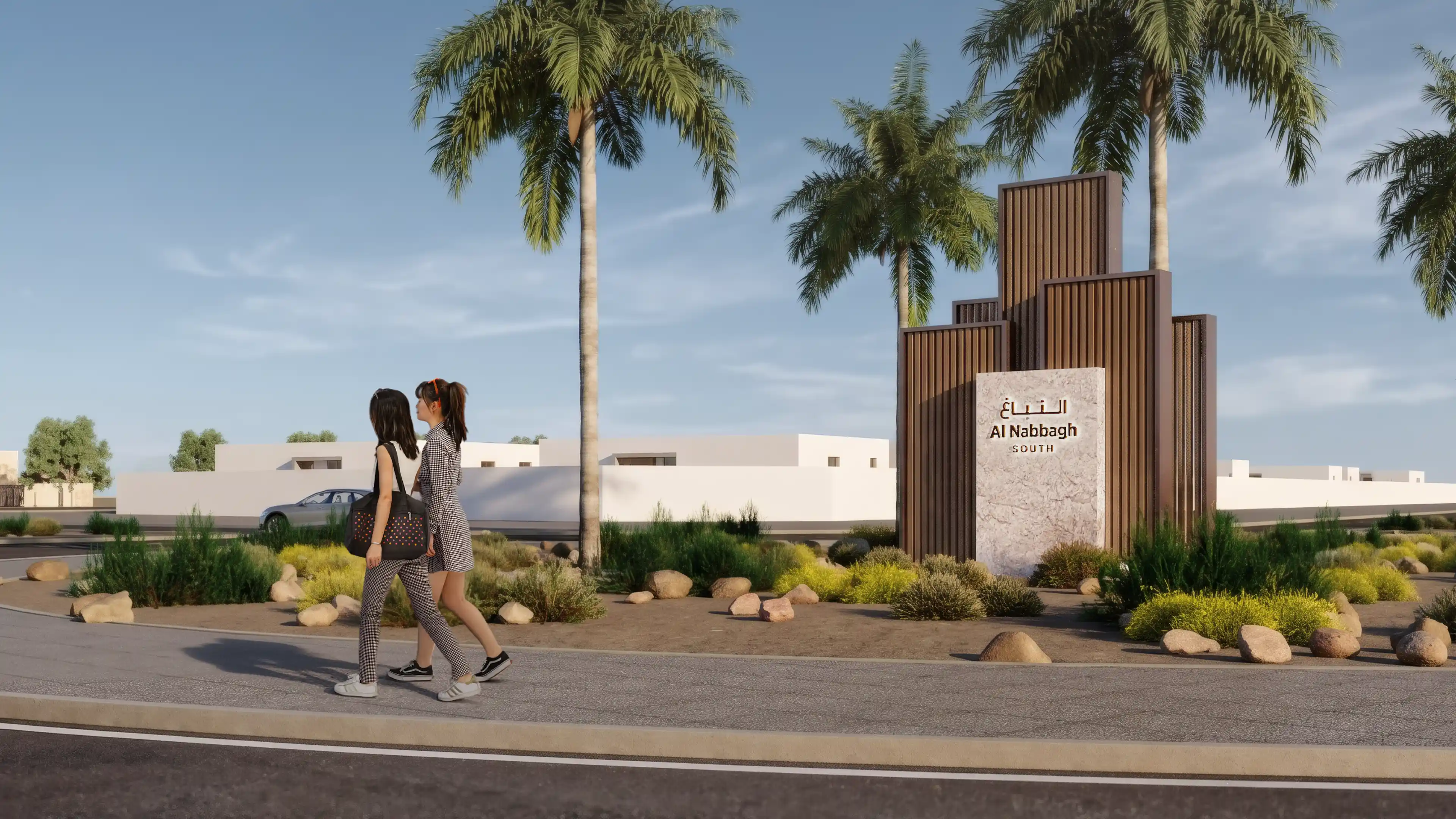
Arrival Experience at Al Nabbagh in Al Ain, designed by LIMAH
Case Study
/

Al Nabbagh

Al Ain, UAE

Al Nabbagh
2022
Case Study
/

Al Nabbagh

Al Ain, UAE

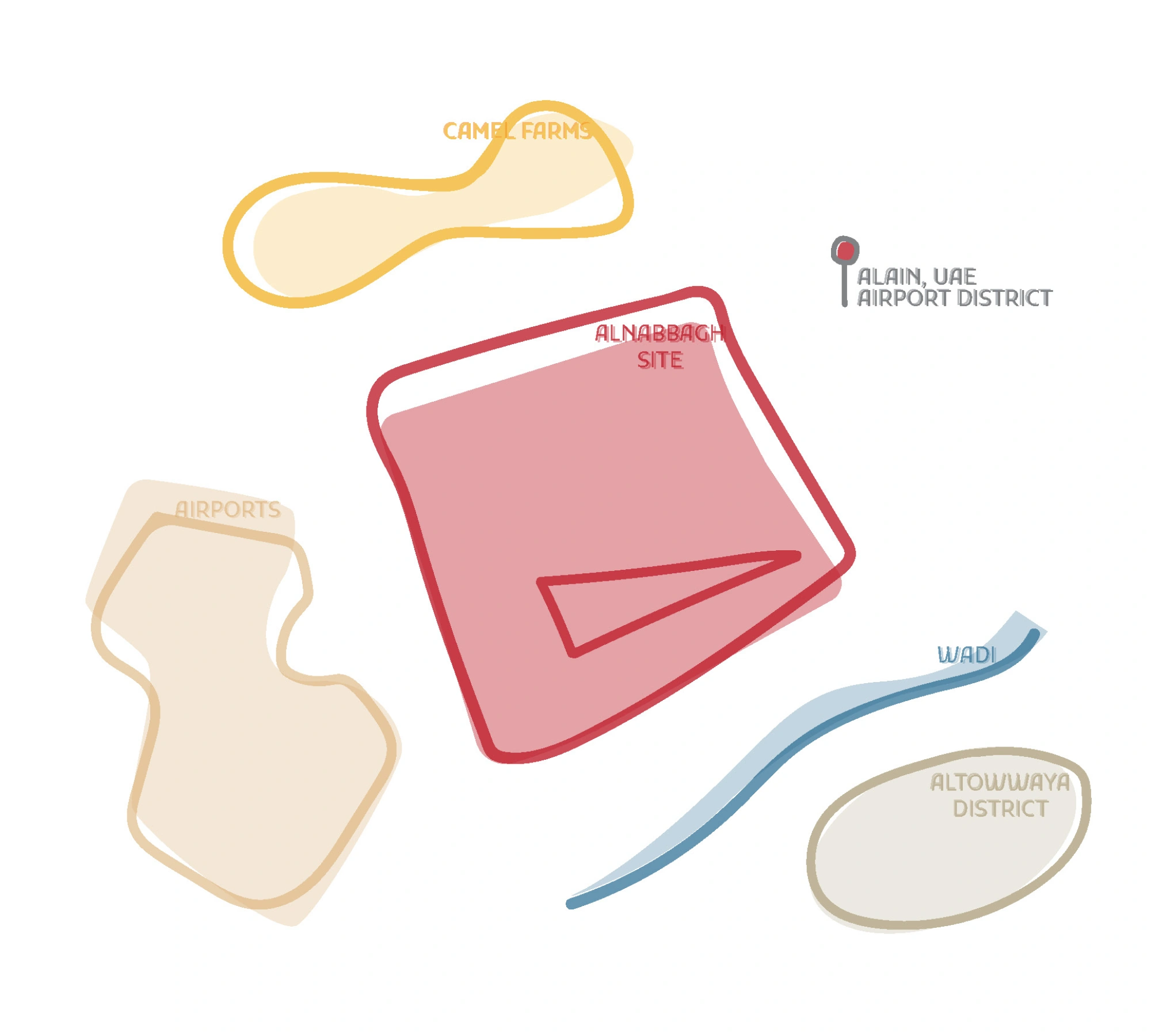
Al Nabbagh sits along Al Ain's northern edge, a residential community positioned between Al Towayya District and the city's airport and aerospace cluster. The masterplan brings together a layered network of vehicular, pedestrian, and cycling routes across multiple development phases, forming a community built around Emirati identity, sustainability, and long-term quality of life.
In collaboration with Insite International, LIMAH was appointed to develop the complete wayfinding strategy and signage product design for the masterplan. The brief asked for a clear, culturally rooted navigation framework that could support residents, visitors, and service users across the full scale of the community while reinforcing Al Nabbagh's identity as a sustainable Emirati place.
The challenge the site presented was one of translation: taking a complex masterplan structure with evolving development phases and intersecting road networks, and making it feel intuitive to the people living and moving through it every day. That process of translation, from plan to place, shaped every decision in the strategy.

‍

STRATEGIC DRIVERS

  • Establish an intuitive wayfinding hierarchy across vehicular, pedestrian, and cycling networks that supports daily residential life and accommodates future growth across multiple development phases.
  • Develop a coherent district division, naming, and addressing system that gives every part of the community a legible identity within the wider masterplan.
  • Align all addressing strategies with Abu Dhabi's Onwani guidelines, ensuring compatibility with emergency services, navigation platforms, and future operational requirements.
  • Reinforce Emirati identity through colour, pattern, and materiality, creating a system that is rooted in local context rather than generic in character.
EXPERIENCE STRATEGY AND DESIGN

MENTAL MAPPING A PLACE

The strategy began with movement analysis: studying the masterplan's vehicular hierarchy, pedestrian routes, cycling tracks, and jogging paths to understand how residents and visitors would move through and within the community. From this foundation, the team grounded the strategy in cognitive mapping, recognising that when consistent cues are reinforced correctly, such as district identity, road hierarchy, and destination prioritisation, people begin to internalise the structure of a place. The aim was not to cover the community in signage, but to reduce the need for it by making the logic of the community legible from within.

‍

Al Nabbagh Cognitive Map

‍

BUILT FOR CLARITY AND SCALE

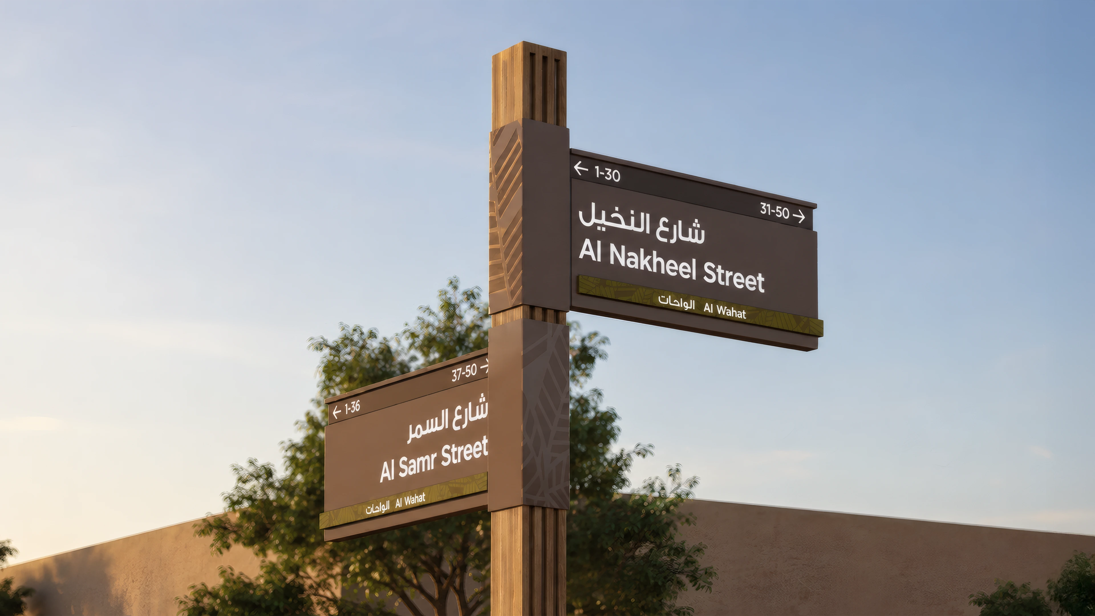
A comprehensive addressing system was developed covering districts, streets, buildings, and villas across the full masterplan. Villa numbering begins from the closest baseline, with odd and even numbers assigned consistently on each side of the street. Road numbering follows a grid logic aligned with Onwani standards, ensuring the system works not just for residents but for emergency services, delivery networks, and digital navigation platforms. Destinations were then classified into primary, secondary, and tertiary levels, following a clear sequence from city to community, district, street, and building, informing sign typologies, message content, and placement throughout the site.

FEATURE MOMENT

COLOR AND PATTERN AS WAYFINDING

Each district at Al Nabbagh carries its own colour and pattern, drawn from Al Ain's landscape and the character of the district itself. These visual identities are embedded into the environment so that residents begin to recognise where they are before they read a sign. The system works with how people actually navigate familiar places, through accumulated cues and a growing sense of the territory, rather than directing them step by step.

‍

NATURAL MATERIALS ROOTED IN PLACE

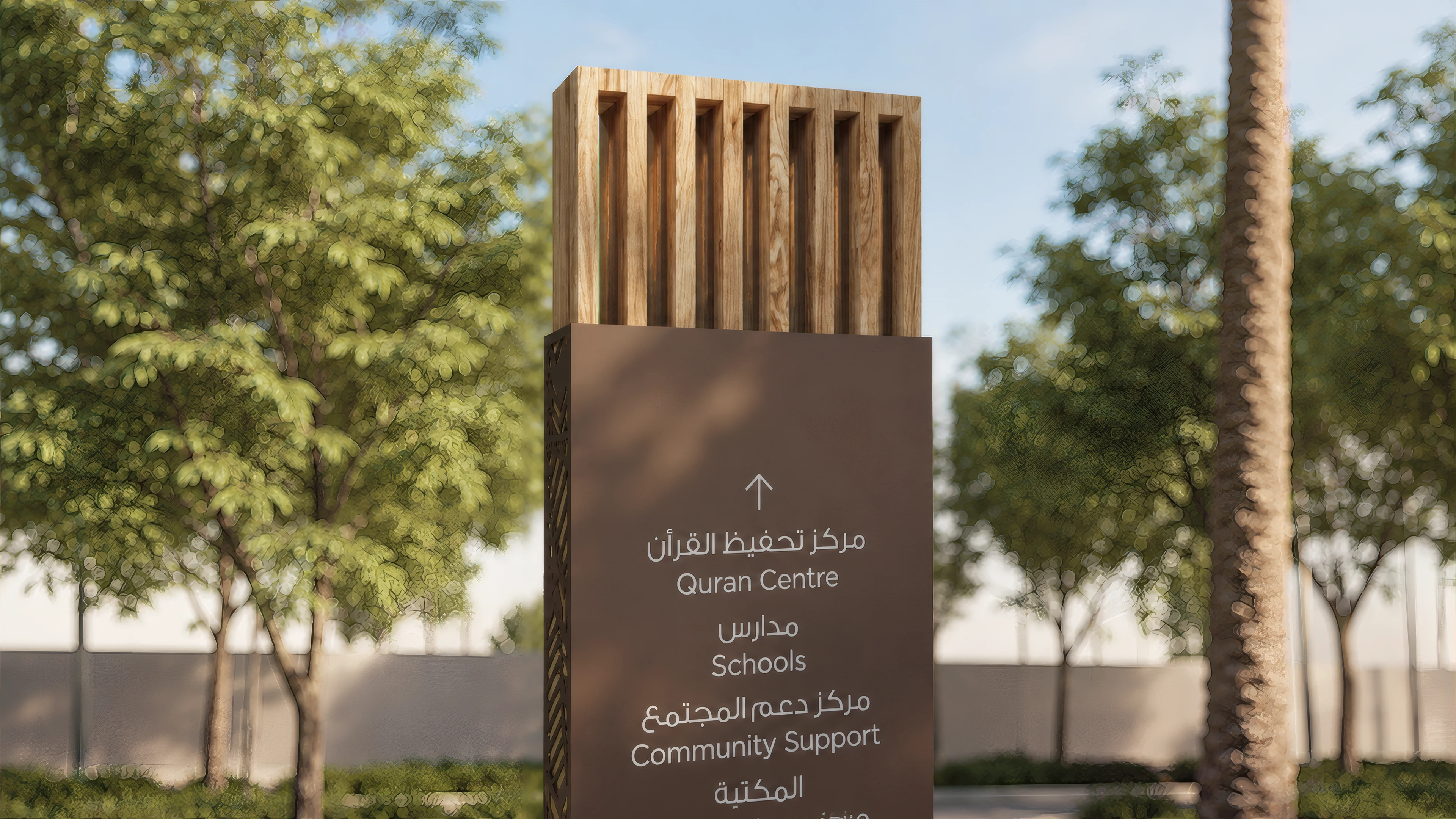
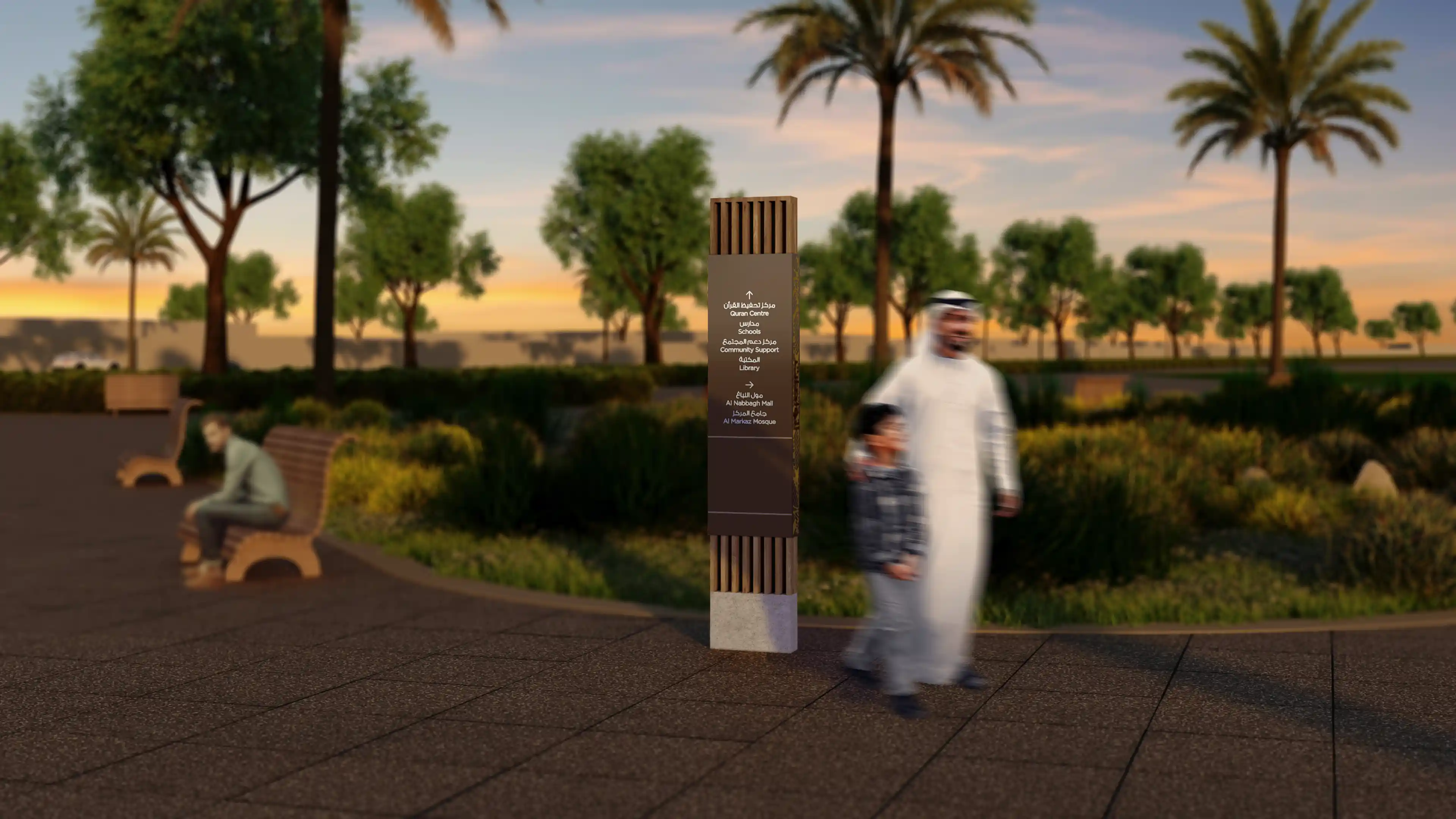
The signage family uses wooden slats, debossed detailing, and layered surfaces to ground the system in the material language of the community. These choices were not decorative. They reflect a commitment to designing something that belongs to Al Nabbagh specifically, that feels as though it grew from the place rather than was delivered to it, and that will continue to feel appropriate as the community matures around it.

No items found.

At Al Nabbagh, a community rooted in Emirati identity now has a navigation system to match. Residents move through their neighbourhood with confidence, visitors find their way without friction, and the streets, districts, and pathways carry a sense of place that extends well beyond the signs themselves. That is what exceptional human experiences look like when wayfinding becomes part of a community's identity.

Arrival Experience at Al Nabbagh in Al Ain, designed by LIMAH
Case Study
/

Al Nabbagh

Al Ain, UAE

Al Nabbagh
2022
Case Study
/

Al Nabbagh

Al Ain, UAE

Al Nabbagh sits along Al Ain's northern edge, a residential community positioned between Al Towayya District and the city's airport and aerospace cluster. The masterplan brings together a layered network of vehicular, pedestrian, and cycling routes across multiple development phases, forming a community built around Emirati identity, sustainability, and long-term quality of life.
In collaboration with Insite International, LIMAH was appointed to develop the complete wayfinding strategy and signage product design for the masterplan. The brief asked for a clear, culturally rooted navigation framework that could support residents, visitors, and service users across the full scale of the community while reinforcing Al Nabbagh's identity as a sustainable Emirati place.
The challenge the site presented was one of translation: taking a complex masterplan structure with evolving development phases and intersecting road networks, and making it feel intuitive to the people living and moving through it every day. That process of translation, from plan to place, shaped every decision in the strategy.

‍

STRATEGIC DRIVERS

  • Establish an intuitive wayfinding hierarchy across vehicular, pedestrian, and cycling networks that supports daily residential life and accommodates future growth across multiple development phases.
  • Develop a coherent district division, naming, and addressing system that gives every part of the community a legible identity within the wider masterplan.
  • Align all addressing strategies with Abu Dhabi's Onwani guidelines, ensuring compatibility with emergency services, navigation platforms, and future operational requirements.
  • Reinforce Emirati identity through colour, pattern, and materiality, creating a system that is rooted in local context rather than generic in character.
EXPERIENCE STRATEGY AND DESIGN

MENTAL MAPPING A PLACE

The strategy began with movement analysis: studying the masterplan's vehicular hierarchy, pedestrian routes, cycling tracks, and jogging paths to understand how residents and visitors would move through and within the community. From this foundation, the team grounded the strategy in cognitive mapping, recognising that when consistent cues are reinforced correctly, such as district identity, road hierarchy, and destination prioritisation, people begin to internalise the structure of a place. The aim was not to cover the community in signage, but to reduce the need for it by making the logic of the community legible from within.

‍

Al Nabbagh Cognitive Map

‍

BUILT FOR CLARITY AND SCALE

A comprehensive addressing system was developed covering districts, streets, buildings, and villas across the full masterplan. Villa numbering begins from the closest baseline, with odd and even numbers assigned consistently on each side of the street. Road numbering follows a grid logic aligned with Onwani standards, ensuring the system works not just for residents but for emergency services, delivery networks, and digital navigation platforms. Destinations were then classified into primary, secondary, and tertiary levels, following a clear sequence from city to community, district, street, and building, informing sign typologies, message content, and placement throughout the site.

No items found.

FEATURE MOMENT

COLOR AND PATTERN AS WAYFINDING

Each district at Al Nabbagh carries its own colour and pattern, drawn from Al Ain's landscape and the character of the district itself. These visual identities are embedded into the environment so that residents begin to recognise where they are before they read a sign. The system works with how people actually navigate familiar places, through accumulated cues and a growing sense of the territory, rather than directing them step by step.

‍

NATURAL MATERIALS ROOTED IN PLACE

The signage family uses wooden slats, debossed detailing, and layered surfaces to ground the system in the material language of the community. These choices were not decorative. They reflect a commitment to designing something that belongs to Al Nabbagh specifically, that feels as though it grew from the place rather than was delivered to it, and that will continue to feel appropriate as the community matures around it.

No items found.

At Al Nabbagh, a community rooted in Emirati identity now has a navigation system to match. Residents move through their neighbourhood with confidence, visitors find their way without friction, and the streets, districts, and pathways carry a sense of place that extends well beyond the signs themselves. That is what exceptional human experiences look like when wayfinding becomes part of a community's identity.

Arrival Experience at Al Nabbagh in Al Ain, designed by LIMAH
Case Study
/

Al Nabbagh

Al Ain, UAE

PUBLIC ART
/
LA MER
2023
Case Study
/

Al Nabbagh

Al Ain, UAE

YEAR
2022
CLIENT
Aldar
LOCATION
Al Ain, UAE
SERVICES
Wayfinding & Navigation
,
Built Environment Integration
,
SECTOR
Cities & Masterplans
,
Residential
,
SHARE BY
https://pb-cb6cbd.webflow.io/projects/al-nabbagh

Al Nabbagh sits along Al Ain's northern edge, a residential community positioned between Al Towayya District and the city's airport and aerospace cluster. The masterplan brings together a layered network of vehicular, pedestrian, and cycling routes across multiple development phases, forming a community built around Emirati identity, sustainability, and long-term quality of life.
In collaboration with Insite International, LIMAH was appointed to develop the complete wayfinding strategy and signage product design for the masterplan. The brief asked for a clear, culturally rooted navigation framework that could support residents, visitors, and service users across the full scale of the community while reinforcing Al Nabbagh's identity as a sustainable Emirati place.
The challenge the site presented was one of translation: taking a complex masterplan structure with evolving development phases and intersecting road networks, and making it feel intuitive to the people living and moving through it every day. That process of translation, from plan to place, shaped every decision in the strategy.

‍

STRATEGIC DRIVERS

  • Establish an intuitive wayfinding hierarchy across vehicular, pedestrian, and cycling networks that supports daily residential life and accommodates future growth across multiple development phases.
  • Develop a coherent district division, naming, and addressing system that gives every part of the community a legible identity within the wider masterplan.
  • Align all addressing strategies with Abu Dhabi's Onwani guidelines, ensuring compatibility with emergency services, navigation platforms, and future operational requirements.
  • Reinforce Emirati identity through colour, pattern, and materiality, creating a system that is rooted in local context rather than generic in character.
No items found.

MENTAL MAPPING A PLACE

The strategy began with movement analysis: studying the masterplan's vehicular hierarchy, pedestrian routes, cycling tracks, and jogging paths to understand how residents and visitors would move through and within the community. From this foundation, the team grounded the strategy in cognitive mapping, recognising that when consistent cues are reinforced correctly, such as district identity, road hierarchy, and destination prioritisation, people begin to internalise the structure of a place. The aim was not to cover the community in signage, but to reduce the need for it by making the logic of the community legible from within.

‍

Al Nabbagh Cognitive Map

‍

BUILT FOR CLARITY AND SCALE

A comprehensive addressing system was developed covering districts, streets, buildings, and villas across the full masterplan. Villa numbering begins from the closest baseline, with odd and even numbers assigned consistently on each side of the street. Road numbering follows a grid logic aligned with Onwani standards, ensuring the system works not just for residents but for emergency services, delivery networks, and digital navigation platforms. Destinations were then classified into primary, secondary, and tertiary levels, following a clear sequence from city to community, district, street, and building, informing sign typologies, message content, and placement throughout the site.

No items found.